WINTER COMING IN LIKE A LION...
- terryswails1
- Dec 17, 2022
- 4 min read
Winter officially starts the 21st of December and while there are some differences in the details, all the available guidance says it should come roaring in like a lion. That means bitter cold temperatures, wind, and snow. Confidence is high in all of these elements occurring. The big question yet to be resolved is whether or not a significant winter storm will usher them in. More on that in a minute.
First, the trend towards wintry weather has been underway for a couple days thanks to the massive storm that's dominated our weather pattern for nearly a week. Late Friday, the energy from that system continues to twirl away over WC Wisconsin having moved very little over the past 24 hours. What a beast. Here's the 500mb flow showing the storm dominating the weather pattern over much of the nation.

Look at the snow the system has laid down over the past 3 days. That's really impressive! The resulting snow cover will also be a factor going forward as cold air masses approaching from the north won't be modified by bare ground. It keeps those Arctic surges like the one that's coming next week nice and fresh.

Remarkably, last weeks storm is still close enough to be a player Saturday. Scattered snow showers will continue to dance around the region but from here on out amounts appear to be on the light side with little if any accumulation before they finally depart Saturday evening. That leaves us with a dry day Sunday as we close the weekend out on a cold note.
SIGNIFICANT (POTENTIALLY HIGH IMPACT) WEATHER CHRISTMAS WEEK
With one major storm in the process of departing the Midwest, new energy is already entering the long wave pattern over the Pacific. The degree of phasing will determine the strength of whatever storm comes of it. Recent trends are indicating another energetic closed low forming somewhere over the central Midwest. The system will have an injection of Arctic air to work with that could lead to explosive development and a high impact winter storm northwest of the surface low.
5 days away, we are still in that window of development where confidence is low on the precise evolution of the key ingredients such as moisture, phasing, intensity, and track. For now the EURO and Canadian GEM are the most bullish on a more direct hit for my area. The GFS is further south.
The most ominous set-up for my region is the EURO which is bombing out a surface low which it currently shows reaching 973mb or (28.73 inches) Thursday December 22nd. A storm of that magnitude would generate extreme winds with a 1048 Arctic high following in its wake. 10 meter wind speeds just off the surface depict gusts of 45 to 60 mph over the central Midwest and Great Lakes. If you notice east of Milwaukee a gust of 78 mph is shown over SC Lake Michigan.

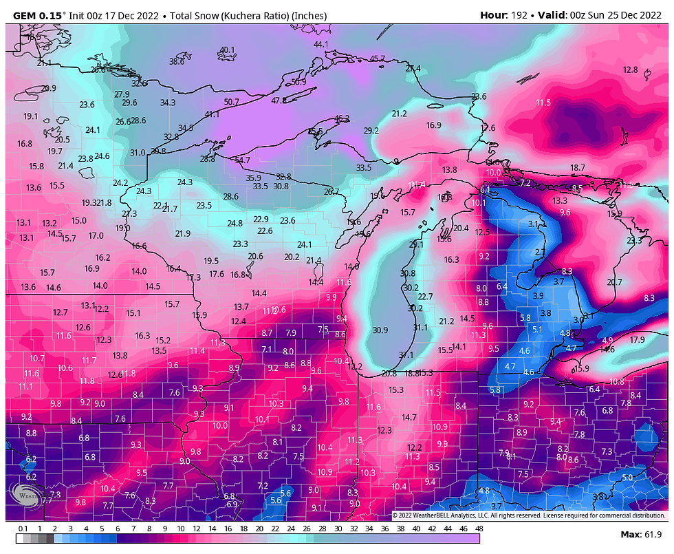
Take those winds and add in snow totals such as this and you have massive travel impacts just before Christmas.

If the snow and wind were not enough, bitter cold air on the back end of the storm sends temperatures to the range of 10-15 below the morning of the 23rd.

Wind chills of 35-45 below are indicated.

The Canadian is in the same ball park as the EURO showing high winds and heavy snow followed by cold.

The GFS is slower to develop and hands the energy off further east before it explodes. That leads to less wind and snow. Even so, some decent accumulations result despite a far different solution.

KEEPING THINGS IN PERSPECTIVE
First and foremost, I highly want to stress, the EURO is the worst case scenario. We are still 120 hours away from the event and until models get into the better data grids of the west coast confidence on some key parameters will remain uncertain. I can't imagine any solution going forward that is worse than what the EURO indicates today (which is a shut-down blizzard). Things can change and undoubtable will, hopefully for the better. The question is how much?
At this point, I do not have the complete picture and I'm anxiously awaiting new pieces of the puzzle. What I want to make clear is that what I do (and have always done) on this site, is show you things that are in the incubation stages. I want you to see what is on the table and allow you to follow my journey and the process of analysis required to make my assessments. Most sources won't say much about the potential at this point, maybe a couple sentences. The reason for that is uncertainty and the fear of being wrong. However, I see no problem in showing you what's out there as long as the message is clear.
SO WHAT'S THE MESSAGE
Personally, I think the potential is there for a major winter storm. I would not put this up if I thought otherwise. However, at this distance I would never buy into a single model or any solution. I'm just compiling evidence and building a case for what looks like some significant weather just before Christmas. Even if the snow ends up on the low end, I'm still confident wind and bitter cold are coming. I do urge pre-holiday travelers to keep an eye on forecasts in coming days. My message is trouble is brewing but to what extent is still unknown. The players are on the field but game is just beginning. We won't know the final score for several more days. Adjustments in the game plan will be made accordingly. Stay tuned and roll weather...TS
TSWAILS PRESENTS, THE LITTLE WHITE CHURCH. ONE OF THE MOST UNIQUE AND ROMANTIC ACCOMMODATIONS IN THE MIDWEST...Click on the banner below to see and find out more


Comments