WELCOME TO JULY...
- terryswails1
- Jun 30, 2022
- 3 min read
Back in the cold dark days of January, thoughts of July were a coping mechanism that allowed me to navigate the slow slog of time leading up to summer. It seems to take forever to get here and once it does, it's over in a flash. Well, here it is once again and I'm determined to appreciate it's heat and humidity because I know, July is a blur, the fastest moving month of the year that always runs its course at an unrelenting pace. I feel you July and I'm glad you're here!
Thursday's forecast is straight forward. A pre-frontal air mass will be in place featuring toasty temperatures but only moderate humidity. Highs should easily reach the upper 80s to low 90s. It looks breezy too with SW winds of 15 to 25 mph at times. The EURO depicts this for highs.

Thursday night a weak cold front makes a slow but steady push into the region from the NW. It should provide enough forcing for a few scattered storms, especially after midnight. However, instability is meager and deep layer shear weak. No severe weather is anticipated and what storms can get their act together will likely be spotty in nature. By late Friday morning the front and any lingering showers or storms will be exiting the south where they will drift out of that region by mid-day at the latest. The hi-res CAMS (convective allowing models) show this for rainfall totals Thursday night and Friday morning. Amounts are generally light (if any at all).
The 3k NAM

The HRRR

Come Saturday and Sunday a weak high pressure will be the force that holds Friday's passing front well to the south in Missouri. That bodes well for my area as relatively dry air by July standards holds sway. That keeps humidity levels tolerable and brings seasonal temperatures in the mid 80s north to the upper 80s south. Some models indicate a small chance for showers and storms late Saturday afternoon or night in my southwestern counties in SE Iowa. Again, I'm not sold on that potential yet. Elsewhere, just some passing clouds are expected.
Thunderstorm chances go up Monday (the 4th) into Tuesday as the front in Missouri turns active and shifts north as a warm front. That is likely to provide the forcing necessary for showers and thunderstorms. We are still too far out to get cute with the particulars such as timing, intensity, and amounts. Mesoscale details that will clarify those issues won't be known for a couple more days. However, the trend is consistent in the latest guidance and confidence is growing that at least scattered showers and storms will be in the area both Monday and Tuesday.
It's also a good bet that by then we are within the ring of fire which increases the chance of MCS development. Those are thunderstorm complexes that form on the nose of heat and humidity, which will also become more noticeable those two days. These are usually at peak strength overnight when the low level jet is at its peak. There is the potential for heavy rain in the areas that end up being impacted. Here's what the GFS and EURO indicate for totals Saturday through next Wednesday. There is a strong emphasis on the heavier rains occurring over my northern counties.
The EURO

The GFS

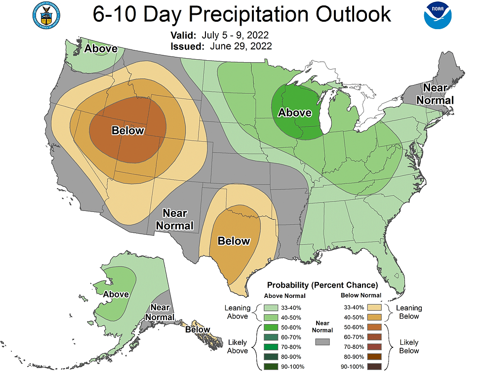
That syncs up well with what the Climate Prediction Center is indicating for rainfall in the 6-10 day period.

See how the heavier rain probabilities above are shown on the northeastern fringe of the heat, or what's known as the ring of fire.

If the overall pattern holds as trends are suggesting, the next two weeks have the potential to see a continuation of above normal rainfall, particularly across the northern half of my area. Here's what the GFS is suggesting for rain totals the next 2 weeks. The south is noticeably drier.

Again, you can see in the 10 day departures July 5-15th how the worst of the heat is situated just to the west putting us in a favorable position to catch ridge riding storm complexes that drop southeast. It will be interesting to watch how the pattern unfolds the first 2 weeks of July.

With that, I say welcome to July and roll weather...TS


Comments