UPDATE ON THE SNOW THREAT...
Snow remains in the forecast for many areas late Sunday night and Monday as a vigorous storm system enters the Midwest. The NWS has issued a winter storm watch for a couple of my counties. I feel it could have been extended further east in Iowa to include my counties near and north of HWY 30 but that's not my call to make.

Back to the topic of the Sunday night Monday storm, it appears that in my region, the area near and north of I-80 will see the greatest accumulations, something that's been advertised the past couple of days. Locations near and north of HWY 30 stand the best chance of seeing 3 to 6 inches of heavy wet snow, locally a narrow band of 7-8" is possible where the strongest forcing is maximized. Most likely that is closer to HWY 20, especially in Iowa. At some point Sunday I expect winter weather advisories will be issued. A few counties in Iowa could go under warnings if things fall into place.
The critical element in this event is evaporative cooling. How much and how soon will determine snowfall amounts. Initially, as precipitation develops temperatures will be warm enough aloft and at the surface for rain to start Sunday night. As the energy approaches and lift and precipitation increases, the air will cool from the top down as colder air is drawn into the system on easterly winds. This will happen last in my southern counties so amounts will be lighter here and some spots may remain all rain in the far south.
That brings us to accumulations. This is what the official NWS forecast is calling for at this time.

Now to the models. The big take-away here is that three major models (the EURO, GFS, and GEM) are all pretty consistent running that snow line near or just north of I-80, so south of there it's mostly a rain event. That's pretty much what the NWS forecast is showing.
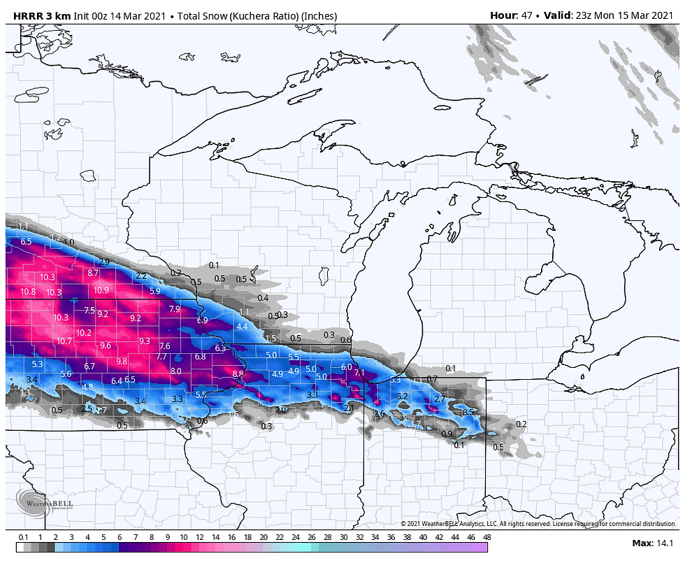
One model that is concerning is the 12K NAM. It's pulling in a small wedge of warm air that off-sets evaporative cooling and keeps the snow band further north and out of Illinois altogether. That makes me nervous. On the other hand, the HRRR is colder and a little further south on the snow band. It's also the heaviest. The 12K and HRRR have both been consistent with previous runs so those are trends we need to keep an eye on Sunday. Bottom line, the best chances for heavier snow are now roughly near and north of I-80, with the largest amounts closer to HWY 30 north. We'll get another day to monitor trends tomorrow. You can see all the model solutions discussed below.
Here's the latest GFS

The EURO

The Canadian GEM

The HRRR

The 12K NAM

Needless to say this is not a slam dunk. The two factors that could cause problems are intensity and dynamic cooling. As you can see the snow totals are higher in Iowa than Illinois because the disturbance fills and slowly weakens as it comes east. That reduces the amount of liquid precipitation and snowfall. If the system weakens faster that could have implications for lower amounts, especially in Illinois.
The other issue with a slightly weaker system is the inability for evaporative cooling to be as significant which could cut into amounts and move them north as well. As a forecaster I always look for problems and the 12K NAM and HRRR have eaten into some of my confidence in how this plays out. I'll be watching to see if the trends they indicate show up in any of the other solutions Sunday.
That's where we are as of Saturday evening. I'll have more for you Sunday as the system closes in and we get fresh data. Roll weather....TS
ONLY 22 COPIES LEFT:
I will take this opportunity to mention that I only have 22 copies left of my book on the most expensive thunderstorm in United States history (11 billion dollars in estimated damage). This will be the final printing. If you are interested in having the most authoritative account of this extreme event I would suggest you act now. Don't miss this opportunity to own the weather story of a generation. You can order yours at derechobook.com
BOOK ENDORSEMENT.
*This book has been quite the talk with the Iowa State Library promoting it. I have never seen the State Library promote any books like this unless it was an award winner of particular interest to libraries. Hopefully your sales are through the roof!
Jolene Kronschnabel-Director of Hawkins Memorial Library, La Porte City, Iowa


Comments