THE CLOCK IS TICKING...
- Jun 19, 2022
- 3 min read
Did you happen to notice how blue the sky was the past couple of days....a deep shade of turquoise? That my friends is due to the quality of the air. A large high pressure over the Great Lakes has allowed premium Canadian air to infiltrate the region. When I say premium I'm referring to the lack of moisture (water vapor). That eliminates haze, allows maximum visibility, and rich blue skies. Here's a sampling of dew points Saturday morning. A far cry from the 70s we sweltered in last week and a key contributor to our fine weather.

Water vapor levels of that magnitude are only 30-40 percent of normal.

That results in relative humidity on the order of 35 percent. Other places in Illinois were as low as 23 percent!

With moisture lacking all around the central U.S., Sunday's weather was about as quiet as you will ever see it in mid June. Check out the limited cloud cover and lack of overall storminess.

Toss into the mix highs in the upper 70s to low 80s and you have yourself some ideal late spring weather.

You might have noticed, I said "late spring weather" above. That's right, technically summer does not arrive until the summer solstice which is Tuesday morning at 4:14 am. The solstice occurs at the moment the earth's tilt toward the sun is at its most direct angle. Therefore, on the day of the summer solstice, the sun appears at its highest elevation with a noontime position that changes very little for several days before and after the summer solstice. The summer solstice occurs when the sun is directly over the Tropic of Cancer, which is located at 23.5° latitude North, and runs through Mexico, the Bahamas, Egypt, Saudi Arabia, India, and southern China. For every place north of the Tropic of Cancer, the sun is at its highest point in the sky and this is the longest day of the year.

By the time we reach the solstice Tuesday, our weather will change dramatically as heat and humidity breach the pattern once again. Sunday (Father's Day) will still be nice by June standards but it will be slightly warmer with highs reaching the low to mid 80s, close to average. For those with outdoor plans, it will be another bright sun-filled day. Don't forget the sunscreen.
THE HEAT IS BACK ON
Monday and Tuesday the heat really fires up again as 850 temperatures near 25C. Southwest winds not only increase the temperature but bring increased humidity as well. Dew points should get into the 60s Monday and by Tuesday evening the EURO has readings near 70.

Then it becomes a matter of how warm we get to determine how high the heat indices go. Current indications are that heat index values will be at their worst Tuesday with the EURO depicting readings of 101 to 104 which would warrant heat advisories.

Tuesday will also be a day to watch for what the EURO thinks could be the first 100 degree day in the Quad Cities since July 6, 2012. I doubt if we actually reach that level, especially if dew points are near 70. The only way we have a shot is if dew points mix out more than expected allowing them to be lower into the 60-65 degree range. Either way, it's pretty much a wash. It's either 100 straight up or its 97 and it feels more like 104. No winner's in that deal.

Here's the locations where the EURO indicates 100 degree highs Tuesday. We shall see.

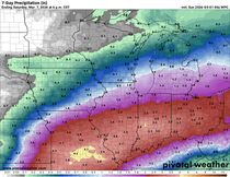
Overall, models continue to look capped and dry through Thursday of the coming week. There is a small rain chance Tuesday night or Wednesday (mainly south) with a front that cools temperatures midweek. Otherwise, models have been trending drier and here's what they depict for rainfall through next Thursday.
The EURO

The GFS

Anyway, it's clear there's not much for storminess in coming days but there will be a heat issue to deal with early next week. Meantime, Sunday should be another fine day and here's wishing all you dad's out there a happy Father's day. I lost mine a few months ago but he's with me in spirit. Whatever cloud you're on dad, I'm thinking of you! Roll weather...TS


Comments