THE BEST SNOW WEEK EVER
- terryswails1
- Jan 8
- 3 min read
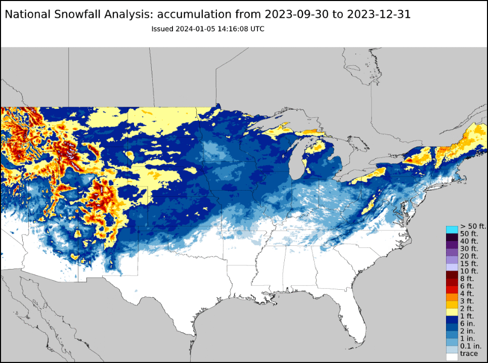
Yesterday I was lamenting the lack of snow this winter, especially with what happened to our south where vast areas of Kansas and Missouri racked up 10–18 inches of white gold. Most of my area (save the far south) never even saw a flake. In fact, while there is still plenty of winter to go, this year is on track to be one of the least snowy ever. As you can see below, there are spots January 7th where only an inch or two of snow has been measured. In SW Iowa, less than an inch has been observed. Many of you celebrate that fact, but for me, it's extremely disappointing.

Virtually all of my area has seen just 10-25 percent of its expected mean snowfall through January 7th.

As I clear my eyes from the tears of pain, I got to thinking about how last year, which was not much better at this point. Going into January, many of us had witnessed just 2–6 inches of snow. About half of that came in November. Bad December sledding once again.

BACK TO BACK BOMBS, HOW GLORIOUS!
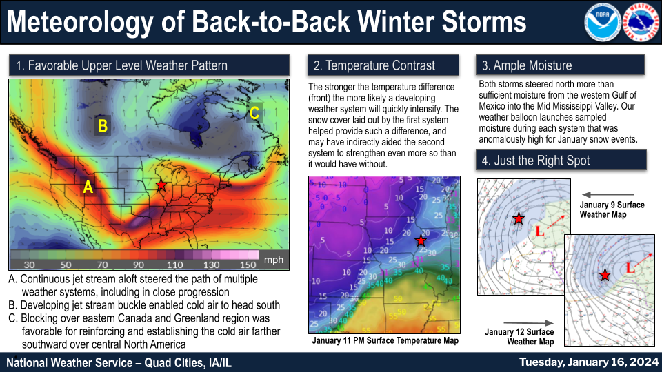
Then came the greatest 4 day snow stretch of snow known in this area. Back to back storms, each dumping more than 15 inches of snow, tuned the barren countryside into a winter wonderland.
The first system plowed into the area January 8th and 9th. EC Iowa took the brunt of it with 10–15 inches of snow from Des Moines to Davenport. 13–15 inches fell from Cedar Rapids to Iowa City.

The 12.6 inches in Dubuque was the most there since 2015. The 14.9 inches in Cedar Rapids was deemed to be the most there since 2009.

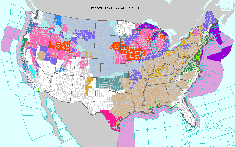
Before it was fully cleaned, a second storm slammed into the area, producing blizzard warnings from western Illinois into much of Iowa.

The main thrust of the storm was centered on the Quad Cities, where 14.9 inches fell at the NWS in Davenport and 17.4 was measured just NW of Geneseo. The 15.4 inches in Moline was the second-highest total for any calendar day!


When the snow stopped, the two storms four days apart, produced 25.5 inches of snow in the Quad Cities making it the snowiest week on record. Dubuque also earned that honor with 24.7 inches.

Following the 2 events, the snow depth peeked at 15-19" at many places. The official calendar day snow depth (measured at 6 AM CST) at Moline, IL was 16" on January 13. Only the winter of 1978-1979 saw deeper snow cover (i.e. 17+"), which was seen on 21 consecutive days! That includes the deepest ever measured of 28".
Winds of 51 mph were measured in Cedar Rapids, with the second storm creating significant drifts areawide. Lows of 16-20 below were established by the 14th, and wind chills of 40-45 below were common.
Remarkably, the pattern soon flipped and by February 1st highs reached 57 in the Quad Cities, 76 degrees warmer than the morning of January 20th at 19 below. Aside from drifts and scooped piles, the snow was gone and the mother of all snow weeks, was just a memory. Oh, how I loved it, and the mere thought of it has me feeling better. Hope that helps to ease the pain for all you snow freaks!

HOLIDAY SALE AT OUR GALENA AIRBNB (CLICK BANNER)
40% off a weekend or weekday stay in December-February. Call or text Carolyn now at 563 676 3320.
GUARANTEED FRESHNESS
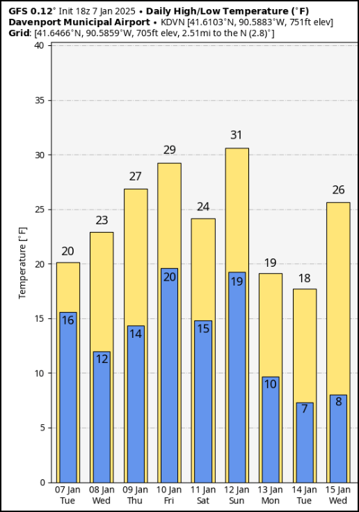
Northwest flow has returned to our weather here in 2025 and while we will see a slight warming trend, temperatures are guaranteed to remain fresh the next week. Highs Wednesday and Thursday will inch back into the mid to upper 20s through Friday.

Precipitation in this pattern looks to be minimal at best. Enough moisture will sneak into the area Friday for additional clouds and perhaps a brief period of light snow or flurries, certainly nothing that would cause any problems.
After that, a clipper with a better surface reflection approaches from the NW Sunday. Again, without much moisture, precipitation should be light but slightly higher with better forcing. It's possible an inch or so could fall, with the north slightly favored. Here's what models are currently suggesting.
The EURO

The GFS

If the system can amplify a bit in coming days, some 2 inch totals may be on the table with a track further south, a solution that is far from certain. Something to keep on the back burner for the end of the weekend. After that, another slug of Polar air charges south, introducing colder temperatures to the region the first half of next week. Have a fine day and roll weather...TS


Comments