SO MUCH FOR THAT PARTY
- terryswails1
- Dec 10, 2024
- 3 min read
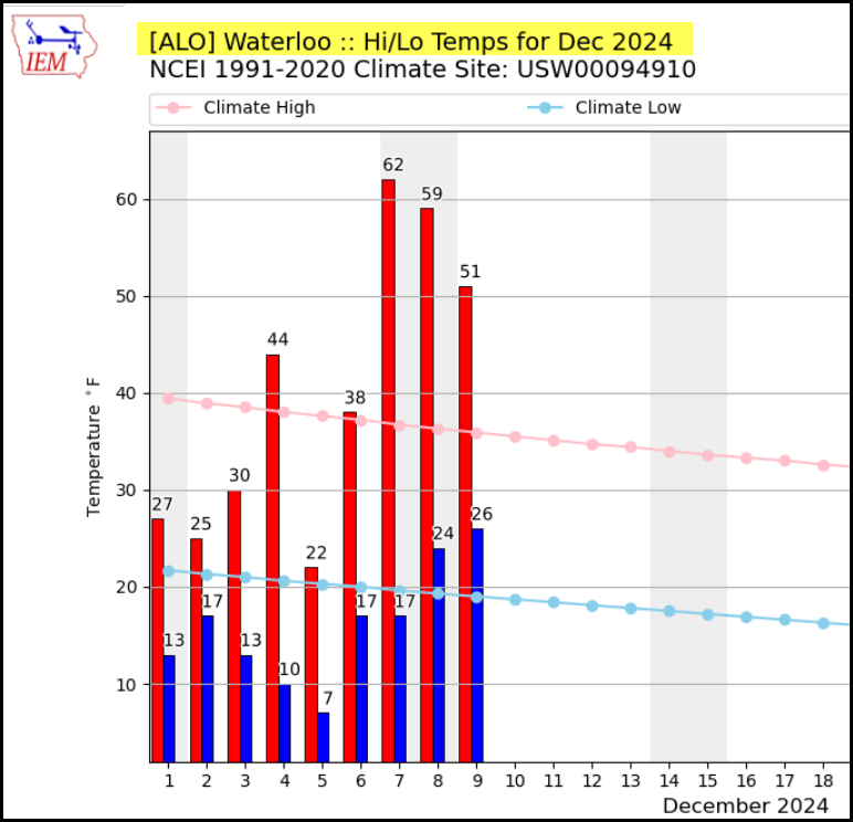
Holiday parties are a dime a dozen at this time of year. One that just concluded had nothing to do with eggnog or sugar cookies, although it was just a sweet. It was put on by mother nature herself and featured a balmy 3-day stretch of mild temperatures. Some places were warm enough to achieve record highs. Steve Gottschalk in Lowden, Iowa reported record maximums of 58, Saturday, 60 Sunday, and 56 Monday. In Waterloo Saturday, the previous record of 57 degrees (set just a year ago), was smashed by 5 degrees with a 62 degree high. That's more typical of October 7th than December 7th!

It's also worth noting that 2 days before the 62 in Waterloo, the low of 7 was 55 degrees colder. Look at the wild swings in Waterloo's temperatures this December, with another big plunge on the way.

Another welcome facet of the party was the fact skies were partly sunny, and it was dry. Everybody could get out and enjoy the friendly conditions. The dryness is getting old, however. The past 3 weeks, we have resorted to the overall trend this fall where we can't seem to scare up any rain or snow. Tuesday, if we do not see anything in Cedar Rapids by midnight (quite likely), it will be the 22nd consecutive day with no measurable precipitation there. That comes on the heels of another exceptional stretch of dry weather August 31st-October 21st, where measurable rain fell on only one of those 52 days, and that only amounted to .05".

HOLIDAY SALE AT OUR GALENA AIRBNB
40% Off a weekend or weekday stay in December-February. Call or text Carolyn now at 563 676 3320
GIFT CARDS ARE AVAILABLE
ANOTHER SHOT OF ARCTIC AIR
While it won't be as windy as what we saw last week, another punishing shot of Arctic air is poised to sweep across the Midwest Tuesday night and Wednesday. In advance of it, a seasonal brand of cold is anticipated Tuesday, with highs ranging from 30 north to 35 south with nothing more than some passing clouds.
The real cold enters the picture Wednesday, reaching its peak Wednesday night into Thursday. Wednesday night 850 temperatures are shown reaching minus 18-20 C. on the GFS. If the reading of -20 can be attained, that will be very near the minimum of that parameter according to SPC climatology.

The HRRR is even colder, showing an 850 reading of -26 in Dubuque Wednesday night. That is wicked, and I'm skeptical that may be several degrees too cold...at least I hope so.

Fortunately we won't have a decent snow cover or lows Thursday could push 10 below. As it is, single digits are expected, with the GFS indicated lows that look like this.

Wind Chills on the GFS mean serious business, reaching 23 below in the north to 14 below south. Wind chill headlines are likely, especially across the north.

Another factor I have not addressed is the potential for some brief but intense snow showers as the cold wrings out any available moisture Wednesday night. These are likely to be banded swaths that could significantly reduce visibility for brief periods of time. It is possible many spots see a dusting, with the strong bands potentially yielding narrow streamers of 1/2 to 1 inch. Here's what guidance is currently suggesting Wednesday night and early Thursday.
The 3k NAM

The HRRR

The EURO

WPC guidance.

After a frosty day Thursday, warm advection returns with a vengeance Friday, allowing some clouds and perhaps another round of light snow showers. If nothing else, it will be warmer, with highs of 27-32 from north to south.
A more intriguing system comes along Friday night that is expected to produce rain, snow or a mix of both. The short wave does have some decent structure and moisture, and therefore should bring better chances of meaningful precipitation. Prospects for snow are tied to the depth of the cold air that remains from the Arctic intrusion Thursday. The GFS holds it in longer than the EURO and thus deposits some respectable 2-4 inch snows, mainly near and north of HWY 30. The EURO allows the cold air to retreat fast enough to produce mainly a rain event, although a few spots in the north could see some minor amounts of snow before mixing with and changing to rain. I can see both sides of the coin. Without a doubt, this events' outcome is low confidence and needs more scrutiny that only time will allow.
Another chance for precipitation exists around December 18th, but I'm not ready to touch that event with the doubt regarding the fore-running system.
Needless to say, after our little fling with spring, it's back to winter for a few days. In fact, there are some interesting developments that will be fun to watch and forecast. Thank goodness. Roll weather...TS


Khelraja's Crazy Time Live game brings you an electrifying, game-show-inspired experience. Spin the wheel, trigger exciting bonuses, and win massive payouts, all while enjoying high-energy live gameplay. With multiple features and a chance to win big, Crazy Time Live offers one of the most entertaining gaming experiences online. Don't miss out on the fun – join Khelraja today!