READY FOR THE WEEKEND....
Rain returned to much of the area Wednesday night and early Thursday. Some spots got a good drink but others in the far south didn't fair so well where the rain was needed the most. Here's the broad view of precipitation around the Midwest.

The heaviest band occurred in a swath that extended from Independence to Clinton and on to Princeton. Some amounts well in excess of an inch were indicated.

As you can see in the latest drought monitor, moderate to severe drought has been expanding over southern Iowa and is now creeping into WC Illinois.

Here's a tighter perspective of the dry conditions over the SW half of Iowa. The ring of fire the past couple of months has been positioned over the NE third of Iowa and northern Illinois producing regular rains and eliminating dry soils in all but my southern 2 tiers of counties.

This rainfall departure graphic from the Iowa Mesonet shows clearly who's been wet an whose been dry since July 1. NC Illinois has been extremely wet, especially Stephenson County!

At least for the next 2 days rain is not expected to be a visitor in my local area as weak high pressure resides overhead. That will provide partly sunny skies and pleasant temperatures through Saturday. Highs Friday should end up in the upper 70s to low 80s. Saturday looks to be a bit warmer with readings climbing into the low to mid 80s. While humidity won't be a major factor there will be enough to feel it, especially during peak heating.
Sunday moisture levels increase to the point that it will become quite muggy. The EURO and most models indicate dew points getting into the low 70s.

The EURO also shows available water vapor reaching 2.00 inches in parts of the region.

The warmth and the moisture will combine to generate some instability. CAPE is shown reaching 1500 to 2,000 j/kg. That's far from extreme but enough to generate thunderstorm potential Sunday and Monday. While some isolated strong updrafts are possible the overall severe threat looks low with weak shear profiles.

Rainfall chances will go up as a slow moving trough begins its slog across the Midwest. Synoptic forcing looks pretty weak both Sunday and Monday so the rains will likely be scattered in nature and not necessarily widespread. However, with the high water vapor any showers and storms that develop are likely to be efficient rain producers, especially with the rich moisture transport and deep warm layer clouds. An inch or more of rain could fall in stronger updrafts but rains of that quality should be spotty.
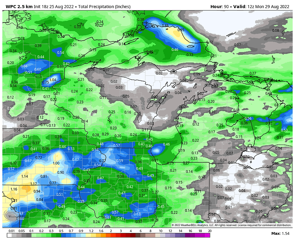
Here's what I'm getting from models regarding rainfall totals. In the end, mesocale details will play a role in where and when the rains fall but at this distance they are an unknown entity.
The NBM (national model blend).

The EURO

The GFS

The Weather Prediction Center (WPC)

Beyond Monday the GFS wants to bring a cut-off low into the central Midwest. With it over the area into Midweek scattered rain chances would be extended into Wednesday. The open wave pattern the EURO suggests would eject any rain from the pattern Monday. That's the solution I prefer. Eventually somewhat cooler and certainly drier conditions will dominate the second half of next week. I like what the EURO meteogram is depicting for temperatures over the next 10 days.

I will end with this. The EURO weeklies which extend to 46 days take us into the first 10 days of October. The control indicates a significant push of cold air aimed at the Midwest the end of September.

7 day temperature departures September 28th-October 5th show the push of cold air. If this were to evolve as the EURO thinks, it could signal the potential for an early frost.

You can also see that by October 10th the EURO is depicting light snow reaching the upper Midwest. Further north the snow pack is building. Hmmm, it won't be long before the north winds bring the unwelcome truth about what lies ahead.

Alright, enough about snow and cold. I'm ready for the weekend and here's hoping yours is a good one. Roll weather...TS


コメント