PATIENCE IS A VIRTUE...
Scattered thunderstorms interrupted sleep across my southern counties early Friday. I was one of those awakened by lightning and thunder before dawn. While the storms made a little ruckus their bark was worse than their bite when it came to rain. Most areas that got rain saw amounts under 2/10ths of an inch. I managed 1/10th of an inch at my place in Le Claire. However, there were a few spots in SE Iowa where more than a half an inch came down. Here are the totals from the NWS in Davenport ending at 9:00 AM Friday. NOTE: (The rain shown around Cedar Rapids and Iowa City fell the previous morning).

Additional rain chances are in the offering this weekend but for most in my area, the next opportunity won't come until later Saturday night or Sunday. Not to say that a few storms (ridge riders) won't clip my northern counties early Saturday but that's far from a sure thing. In general, Saturday looks to be warm, dry, and capped with a warm front and its forcing well to the north in Minnesota. Highs should make it well into the 80s with a few spots out west pushing 90. With dew points up around 70 a muggy day is in store.
Saturday night through Sunday night thunderstorm chances increase as a trough digs in from the west. That enables the jet to strengthen and act on the instability generated by the warm humid air mass in place. An MCS (thunderstorm complex) will likely form on the nose of the low level jet in NW Iowa and SW Minnesota Saturday evening and then track southeast around the ridge aloft. The strength of the cold pool will determine the intensity of the storms as they reach my area and whether they can hold together after they reach the Mississippi later Saturday night.
Sunday and Sunday night thunderstorms are likely, especially after peak heating and into the evening. CAPE values could reach 3,000 j/kg which is sufficient for a few strong to severe storms with better shear in place. PWAT's (available water vapor) look to be up around 2 inches which would also imply heavy rain from the stronger updrafts. If you are looking for rain, patience is a virtue, just give it another 24-36 hours.
Over the next 5 days the weather prediction center indicates rain totals that look like this.

The national blend of models NBM has this for the same period.

Saturday WPC even shows a slight to marginal risk of excessive rains just to my west.

Sunday a slight risk of excessive rain is indicated over all of my area.

The next order of business is a tentacle of heat which makes a run at my area next week. The Weather Prediction Center is showing excessive heat in its day 3-7 hazards outlook that reaches into my counties in SE Iowa.

As it looks now my area stands a good chance of seeing highs in the upper 80s to low 90s Sunday through next Thursday. With dew points projected to be in the low to perhaps mid 70s during this period sultry conditions are a sure bet. There may be a couple days where heat index values hit 100, especially across the south. The GFS rolls the heat right on through next weekend. Look what the meteogram for Waterloo is showing. It has 9 days where highs are in the range of 98-102 degrees. 5 days 100 or better!

There is no way that is going to happen. I can see support for very warm temperature into Thursday while the MJO (Madden Julien Oscillation) is in phase 1. However, it quickly rotates into phase 2 which the analogs clearly show is not conducive to the heat the the GFS indicates. The operational GFS is not in sync with its own MJO forecast and that leads me to believe it's in fantasy land with regards to prolonged intense heat.

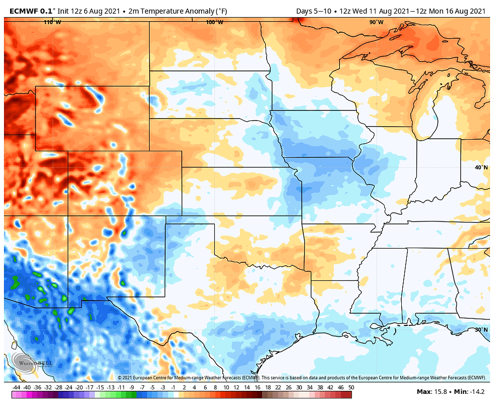
To confirm that, the EURO also goes into phase 2 with its MJO. Instead of showing heat, its day 5-10 temperature departures are actually below normal and far more in line with what phase 2 should look like above.

With the MJO making a run through phase 2 my expectation is the GFS will change its tune and Waterloo and many other parts of the central Midwest will not suffer through the intense heat the GFS is depicting.
With that, it's time to call it a post. Have an excellent weekend and roll weather....TS


コメント