ON TO THE NEXT "SNOW" STORM...
Low pressure associated with a late winter storm tracked through southeast Iowa early Tuesday creating rain, freezing rain, and even thunderstorms with hail. On the satellite below you can see the dry slot (in yellow) poking into
my southern counties ending precipitation late Tuesday morning. The deepening surface low is located just southeast of the Quad Cities. Widespread showers and thunderstorms are off to the east while snow is falling from NW Iowa into Minnesota and Wisconsin. Freezing rain or drizzle is occurring over EC Iowa and SW Wisconsin.

Below you can see how temperatures SE of the surface low are in the mid 50s while in NE Iowa readings have plunged into the mid teens. The freezing line is just northwest of the Quad Cities. North of that line is where most of the freezing rain fell. Amounts were generally less than 1/10th of an inch although a couple spots had up to 2/10ths.

Overall, that was about what I expected. The NWS had advisories all the way to the Quad Cities which I think verified pretty well. I did not have any freezing rain at my place in Le Claire but other places in the metro may have.

Another interesting aspect of the storm was the thunderstorms which rolled through the Quad Cities around 3:00am. At that time you can see a healthy core coming up from the southwest just north of the warm front in southeast Iowa.

The elevated storms were hailers. You can see the special weather statement issued by the NWS in the Quad Cities for the cell and its potential to produce gusty winds and penny sized hail. To the right is a picture of dime sized hail which covered the ground and road. I watched the lightning from my bedroom and it was pretty hot for a time. A real bonus for February 22nd. I had some hail but nothing like other parts of town.

That disturbance is long gone but the mean trough remains over the west and another piece of energy is getting set to round the bend and head for the Midwest Thursday night. With this system there will be no question regarding precipitation type as temperatures will be plenty cold enough for the white gold. Advisories will likely be issued for much of my area later Wednesday.

Below you can see the Weather Prediction Center has issued healthy odds for at least an inch of snow in many parts of the central Midwest.

This will be a fluffy light snow with snow ratios greater than 15:1. It will be easy to move and should fluff up enough to produce totals in the 1-43 inch range. The winter storm severity index indicates only minor impacts. However, there will be slick roads so keep that in mind, especially Thursday night.

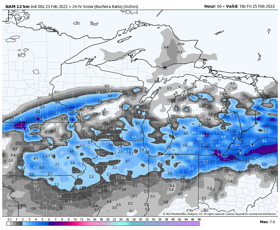
In terms of a storm, this event is far from impressive with little moisture and meager surface development. However, what ingredients are available appear to all come together at the right time to take advantage of the forcing. Confidence is high on accumulating snow and moderately so on placement and amounts. For much of my area current indications support a general 1-3" snowfall with lots of fluff. Currently, models are showing snow totals that look like this. These are not forecasts but in a general sense I think they accurately represent the trends.
The EURO

The GFS

The 12K NAM

The 3K NAM

After this disturbance the pattern turns far less energetic and the weekend looks quiet but cold. Readings with fresh snow cover will be well below normal Friday with highs remaining in the low to mid 20s. Some moderation is anticipated beyond that with highs going from 30-35 Saturday to 35-40 Sunday. It's nothing special but certainly not a bad way to close out the last weekend of February! Roll weather...TS
PLEASE CONSIDER SUPPORTING TSWAILS...
Hi everybody, I'm asking that those of you who find value in the site to consider a $12 dollar voluntary subscription covering operating expenses and the time and effort I put into the site. My $12 dollar asking fee is the cost of a pizza or a dozen donuts. Those are gone in a day, TSwails.com is here for you all year long. It's a heck of a value and all I'm asking is that if you enjoy the site and see value in it, that you please consider a voluntary subscription. I'm asking $12.00 dollars a year. That's $1 dollar a month or 3 cents a blog. Thank you for your support and consideration. Terry


Comments