


MEGA WINDS, PLUS TYPHOON MONKEY WRENCH...
MODERATE RISK FOR SEVERE THUNDERSTORMS NOW IN EFFECT FOR PARTS OF IOWA. THE LATEST ON AN EXTREMELY RARE DECEMBER SEVERE WEATHER OUTBREAK IN THE SECOND HALF OF THIS POST...
For a couple weeks I've had my eye on the MJO (Madden Julien Oscillation) as the precursor for a pattern change that would bring a more wintry brand of weather to the Midwest around the 22nd of December. Something that was not anticipated was a strong typhoon (Rai) which is set to strike the Philippines. It's flirtation with the Indian Ocean where the MJO is measured is slowing the progression and actually retrograding the MJO's cycle. If you look at the phase diagram below you can see the dotted green line today is just reaching phase 7 (a cold phase in December). But, it abruptly halts, turns around and goes back into 6, the warm phase we've been in recently. That is likely tied to the tropical influence of the typhoon.

However, that only lasts a few days and around December 22nd (with Ria gone), the MJO resumes its push back into phases 7 and 8...as was indicated in forecasts that go back 5-10 days. This dang typhoon turned into a monkey wrench. Again, here's what the temperature analogs for phases 6 through 8 look like in December.

This is the projected track of RAI through the Philippines toward SE Asia.

It's also a well know teleconnection that when tropical cyclones go east of Japan there is a downstream reaction in the form of a trough in the eastern U.S. that brings cold. The opposite occurs when the storm goes south or west of Japan resulting in more of a west coast ridge which results in milder pattern over the Midwest. The temporary retrograde to phase 6 makes sense as the typhoons path retains mild readings for a few more days.

I did read the discussion from the climate prediction center and they say this: The MJO is forecast to destructively interfere with the low frequency La Nina base state, which may slow down or even slightly retrograde its propagation in the near term as indicated by the GEFS and ECMWF ensembles. However, both models indicate enhanced upper level divergence extending east of the Date Line, suggestive of renewed eastward propagation of the intraseasonal signal through RMM phases 7 and 8, by week-2. Although, there remains considerable uncertainty due to the large ensemble spread, it appears that this MJO event has the potential to advect positive subsurface ocean temperature anomalies over the West Pacific eastward across the remainder of the equatorial Pacific, which could result in a weakening of the negative sea surface temperature anomalies over the Nino regions over the next 2 weeks.
My interpretation of all this leads me to believe that somewhere around Christmas things are going to go the way of the MJO and we will get into winter. I've never known the MJO to fail to deliver cold this time of year when the phase and temperature analogs show it. Maybe the MJO forecasts bust, the La Nina is too strong, or climate change overwhelms the previous analogs and they have become outdated and I'm way off base. All I can tell you is the past month has been a nightmare to forecast with no model having much of a track record for consistency beyond 3-4 days. Nothing would surprise me going forward. That said, the CFSv2 does show these temperature departures Christmas through January 4th. At least that's going in my favor. We'll know soon enough.

GIVE THE GIFT OF WEATHER SCHOOL. TSwails.com is offering a very special opportunity for you to learn first-hand the ins and outs of severe weather forecasting with one of the most experienced meteorologists in the country and a talented team of experts. Get the agenda, more details, and limited session seats by clicking the banner below.

A HIGH END WIND EVENT.....
Today's the day that a significant and potentially historic wind event is possible over the central Midwest, especially from the Mississippi west late Wednesday and Wednesday night. Ahead of the deepening storm center and associated cold front, a very steep pressure gradient is forecast to develop. The maximum rise fall couplet is projected to arrive at the same time as an 80kt+ jet max at 850mb (only 5 miles up). That's a volatile combination and sustained winds up to 40 are possible with gusts as high as 60 to 80 mph. Below, the GFS shows 10 meter winds (30 feet above the surface) reaching 87 mph in northeast Iowa. How much of that wind energy aloft can mix down to the ground will determine how high we go but this is looking more and more like a high end wind event. Especially when you consider severe thunderstorm warnings are issued for winds of 58 mph or greater!

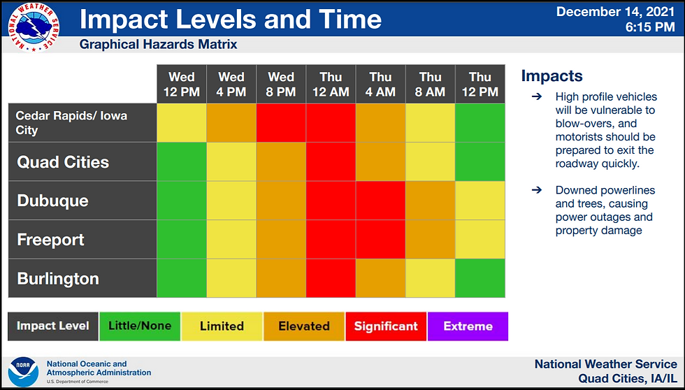
The NWS has issued High Wind Warnings Wednesday afternoon into Thursday morning.

This graphic shows that while winds will be strong during the afternoon gusting to 40 mph, the highest gusts are anticipated in the evening near the advancing cold front. Exceptional gusts are a threat then when the dry line punches through. The rapid subsidence and drying promotes a favorable environment for transporting higher momentum air aloft to the surface. If any of those 75-80 mph winds just off the deck are realized at the surface we will have problems. I would highly suggest that if you have anything outside of value that can blow around to secure them or bring them in. High profile vehicles may want to stay in park during the worst of this. Winds may relax for a short time following the dry line but dramatic pressure rises will increase winds again before midnight as the storm sweeps into the upper Midwest.

As you can see in this NWS graphic, winds are going to produce elevated or significant impacts for about a 12 hour period Wednesday night and early Thursday.
Already pressure falls in response to the storm have generated lots of warm air advection which is pulling warm moist air northward. Overnight temperatures have been rising and clouds have been on the increase. By morning some sprinkles or drizzle will be possible but the day starts very mild by December 15th standards.
Eventually we are expecting some breaks in the clouds and with the strong south winds by mid afternoon we should all be enjoying record high temperatures, some which could threaten to break all-time records for any December day. Here's what we need to get the gold star.

This is what the EURO indicates for highs. Some areas are likely to break Dec. 15th records by as much as 15 degrees. All-time December records are in the upper 60s to low 70s for the stations above and they are also very much in jeopardy.

These are Wednesday's projected temperature departures, readings will be running 40 degrees above the norms!

SIGNIFICANT SEVERE WEATHER THREAT FOR PARTS OF THE REGION.
The thunderstorm threat is another significant aspect of this system that is questionable for my area, especially when it comes to severe thunderstorms. You can see below that the GFS is indicating a broken line of storms around 8:00PM as the cold front is streaking across Iowa. You can also see that tight pressure gradient creating powerful winds throughout the Midwest.

A couple of key factors that could limit any severe weather in my area is instability and low level shear. CAPE values are only shown reaching 400 to 700 J/KG, nothing impressive. That limits updraft potential. Along with that, the crazy low level shear near 50 KTs near the surface may tear them apart if they try and go up. However, a little more sunshine and instability and those issues are overcome. Then we would get into a situation where low topped high shear supercells would be a factor with some tornado potential and intense downdrafts. I think the threat is greatest just to the west of my area, especially since the storms would not reach the bulk of my region until well after dark when the marginal instability that exists will be decreasing. That said, we are in uncharted waters with this scenario. I do not ever recall a moderate risk issued in Iowa this late in the year, especially December. There are few if any severe weather analogs to compare it to. Even if we just get garden variety showers they may mix down enhanced gusts. It's a crazy set-up.
As it stands now, the Storm Prediction Center has a moderate risk for severe weather in place just to the northwest of my local area. It's surrounded by an enhanced and slight risk that covers much of the rest of my counties in eastern Iowa. Severe wind gusts are the primary concern but there is a conditional tornado threat in counties near and northwest of Cedar Rapids. I plan to have a live Facebook post on the latest potential around mid-day Wednesday when conditions should be clearer.

Needless to say, Wednesday is going to be a big weather day no matter how it plays out. I expect wind ends up being the primary severe weather element and hopefully gusts are contained to a range where impacts are manageable and damage is isolated. Fingers crossed. Stay tuned for my updated video briefing around mid-day Wednesday. Roll weather...TS
PLEASE CONSIDER SUPPORTING TSWAILS...

Hi everybody, I'm asking that those of you who find value in the site to consider a $12 dollar voluntary subscription covering operating expenses and the time and effort I put into the site. My $12 dollar asking fee is the cost of a pizza or a dozen donuts. Those are gone in a day, TSwails.com is here for you all year long. It's a heck of a value and all I'm asking is that if you enjoy the site and see value in it, that you please consider a voluntary subscription. I'm asking $12.00 dollars a year. That's $1 dollar a month or 3 cents a blog. Thank you for your support and consideration. Terry


Comments