INTO THE FRYING PAN...
- terryswails1
- Aug 18, 2023
- 3 min read

For those of you out and about early Friday, you are in the midst of a spectacular morning. Fair skies and temperatures down around 50 are the direct result of a high pressure and its dry air. Those ingredients the remainder of the day would normally constitute the makings of a picture perfect day. However, the alignment of the upper level winds will allow smoke from Canadian wild fires to make an appearance. Hazy skies will be the clue the smoke has arrived.
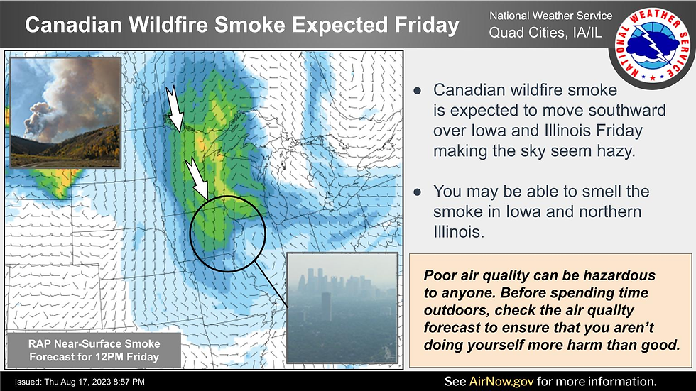
Aside from that, look for highs in the upper 70s to near 80 with a light wind regime and virtually no humidity. My advice, enjoy the comfortable temperatures as there is going to be a steep price to pay going forward.
Before we get to the heat, the new drought index has been published and despite some nice rains the past couple of weeks, soil conditions remain dry over many parts of the central and upper Midwest. In my area, a large part of eastern Iowa is still considered to be in moderate to severe drought. Most other locations are still abnormally dry.

Considering what's to come (hot, rain free weather), the situation is not likely to improve and may actually worsen going forward. That's all due to a blast of hot air that attacks the central U.S. over the next 7 days. The reason for the steam is a heat dome that's in the process of building to significant proportions in coming days. This animation shows the core of the upper level ridge feasting on the Midwest during the period Sunday-Thursday before breaking down.

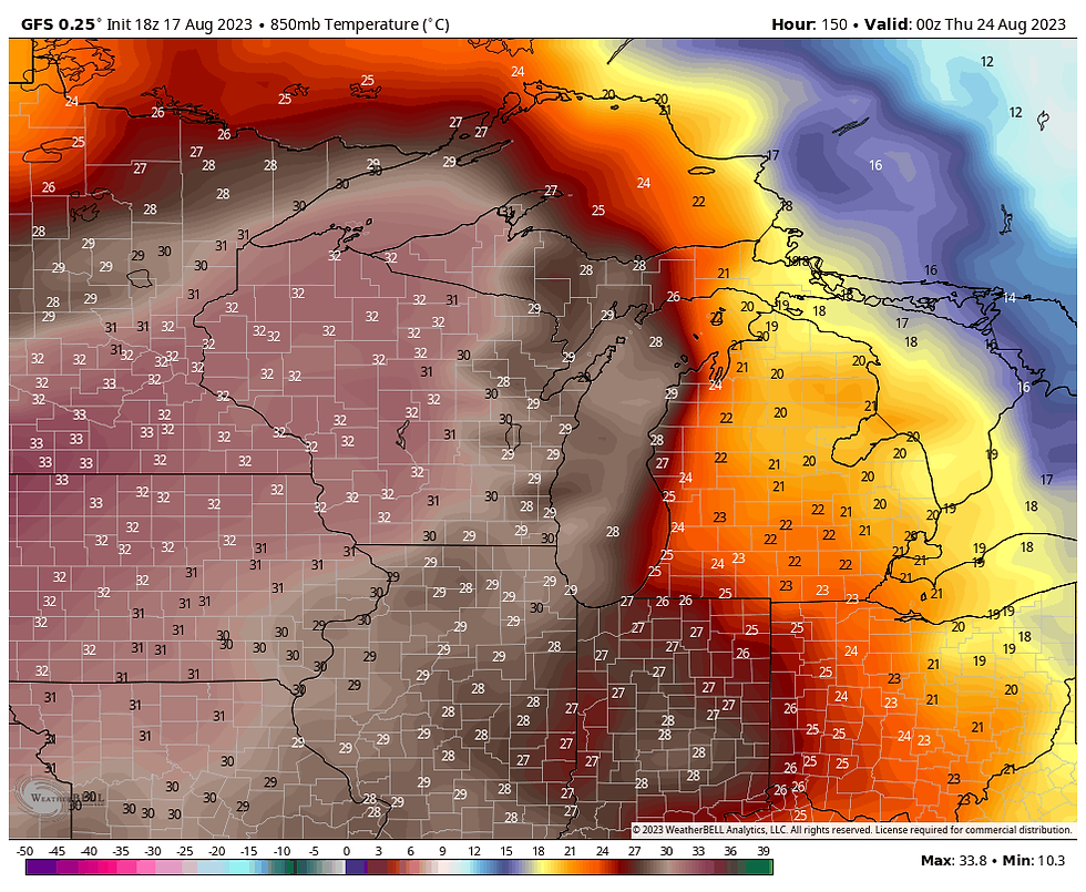
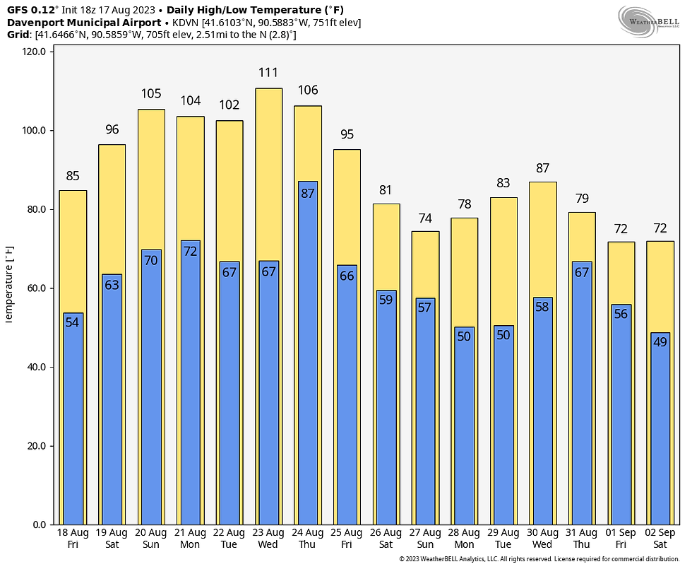
The GFS indicates 850 temperature (at 5,000 ft.) reaching 31 degrees C. (88 degrees F.) Wednesday. That is a level rarely seen and it could mean actual highs Wednesday end up near 100 degrees.
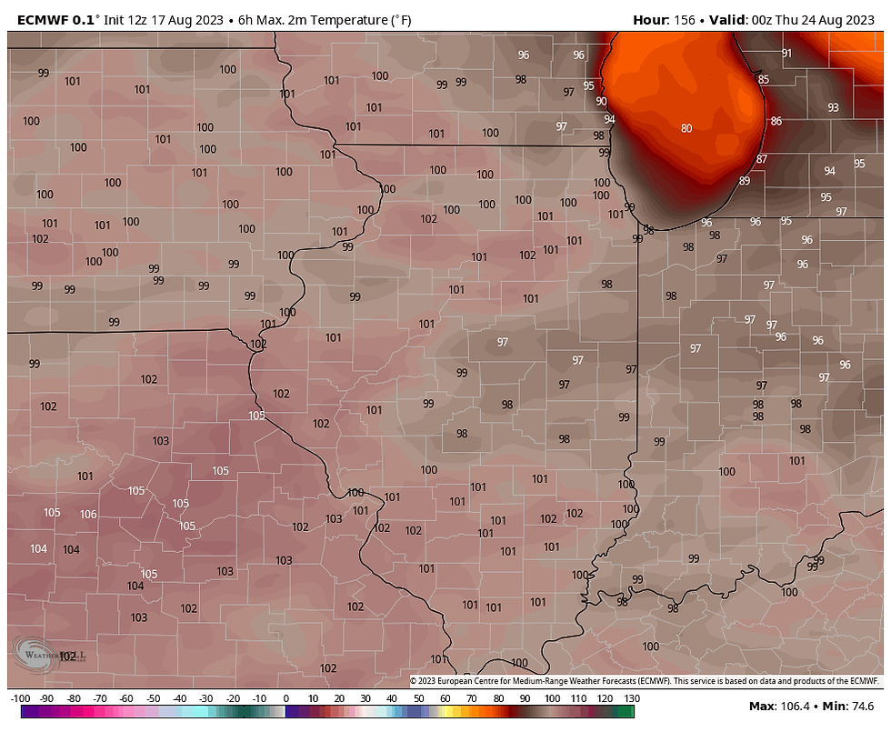
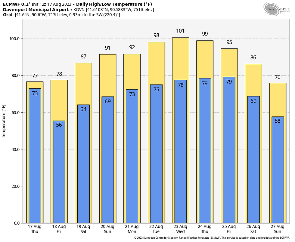
Even the EURO, the coolest model has highs Wednesday of 99-102. For all but my southernmost counties down around Keokuk, it's been at least 11 years since the last 100 degree reading.
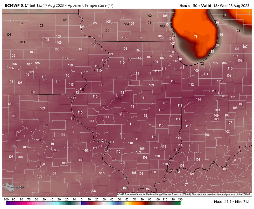
Toss in dew points in the low 70s and heat index values are shown at 105-113 over all of the central Midwest!
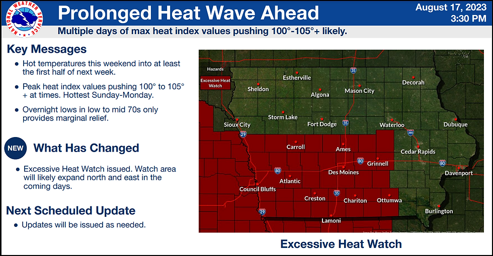
The NWS in Des Moines has issued an excessive heat watch just to the west of my area for Sunday and Monday. It's possible that it could be pushed east, or some other form of heat advisory or warning could be issued for my region in coming days.
While it's still early in the game, the EURO meteogram shows these high temperatures in the Quad Cities through August 27th.
The GFS is unusable and you can see why with highs up to 111 next Wednesday.
Due to the strength of the heat dome and our proximity to it, rain chance through Thursday of next week are minimal due the stout eml (CAP) from the warm air aloft and subsidence (or sinking air). The GFS shows this for rainfall the next 7 days.
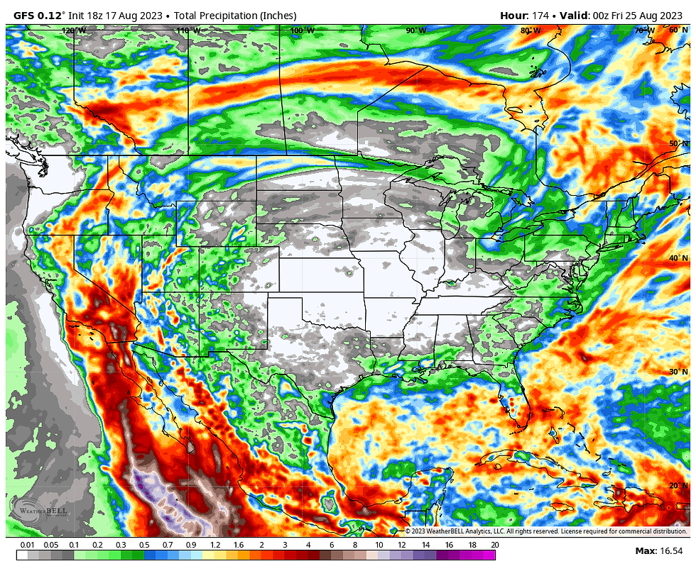
The departures are significant and widespread over much of the nation which is why the drought is likely to worsen or expand over the next week.
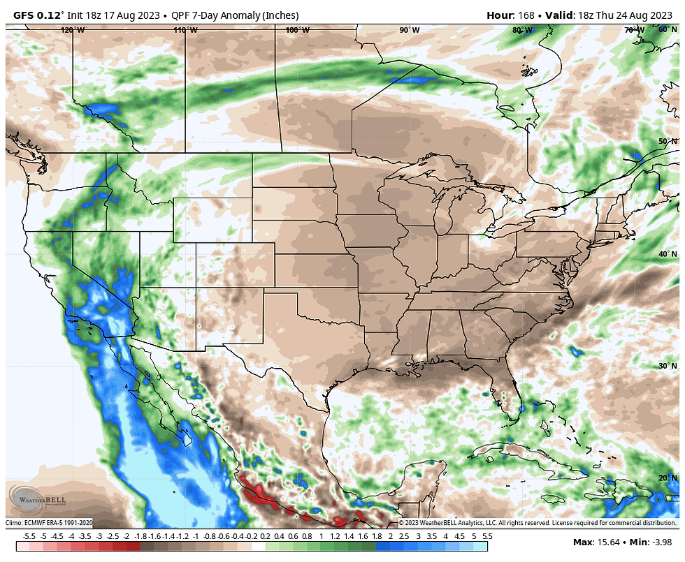
Hot, steamy, but dry is the name of the game starting Sunday. We're headed for the frying pan. Happy Friday and roll weather...TS
A SPECIAL DEAL FOR TSWAILS USERS, (BUY 2 NIGHTS, GET THE 3RD FREE)
NOW THIS IS "SPECIAL"
Hey everybody! I've got some openings the next few weeks at my AIRBNB, The Little White Church of Galena. I would like to fill it up and that means I'm willing to deal. Contact us direct and we can eliminate the AIRBNB fees and taxes. That means big savings for you. Weekday rates are especially good. ASK ABOUT OUR BUY 2 NIGHTS, GET THE 3RD NIGHT FREE DEAL. The newly remodeled church includes 3 bedrooms, 4 HD TV's, high speed internet, all in a beautiful country setting. All of our reviews are 5 STAR. There's no better time to enjoy Galena and all it has to offer. Split the cost with friends and family and we'll set you up with a deal that's as good as it gets. Call or text Carolyn at 563-676-3320 or email carolynswettstone@yahoo.com We would be thrilled to have you as guests!


コメント