FRESHNESS GUARANTEED
- terryswails1
- Jan 9
- 2 min read
High pressure was in full control of the weather around the Midwest Wednesday, resulting in cold temperatures and a full day of sunshine. The fair skies provided the perfect conditions to see where snow is (or is not) on the ground. The picture was snapped from 22,000 feet.

Here's another perspective which allows a better view of the weekend storm that buried our friends to the south in Kansas, Missouri, and the southern half of Illinois.

There's a huge swath from Kansas to Indiana and Ohio, where 6-12 inch snow depths are common.

Notice the impacts the snow has on temperatures. Where it's deepest (12–15 inches) in NE Kansas, readings are 22-26 degrees below normal Wednesday afternoon. Relative to average, temperatures to our south are much colder than here due to the influence of the deep snow cover.

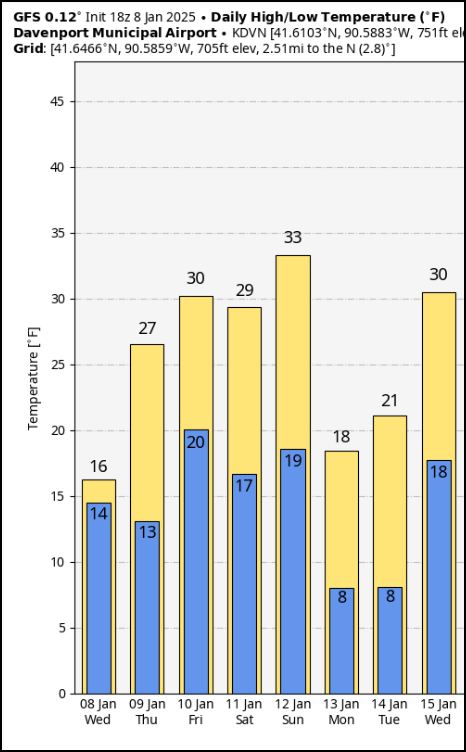
All things considered, temperatures are guaranteed to stay fresh through the middle of next week, with highs near to below typical January levels. We will get a little bump Friday as a wave passes well to the south.

As it pulls in slightly warmer it, it also tries to send some moisture northward. About the time this reaches our area, it's intercepted by a weak cool front and forced east. That said, there will be a short window where some light snow or flurries are possible, especially southeast of the Mississippi. In my area, most spots NW of the Quad Cities will see little if any accumulation, with amounts southeast of there of an inch or so. Here's what models are suggesting for totals at this point.
The EURO

The GFS

The 12k NAM

Saturday looks uneventful, and then attention turns to a clipper that drops into the Midwest Sunday. This system has decent upper air support and surface reflection. While it should be a good 2-5 inch snow producer, the track over the NE tip of Iowa should keep those heavier amounts just to the north of my area (another miss). Even so, enough warm air advection is expected to produce a brief period of light snow that could mix with some freezing rain or sleet at times. Up to an inch of snow is possible, mainly north of I-80. Here's what is currently shown for snow amounts.
The EURO

The GFS

While we play with nickle and dime stuff from time to time the nest few days, the deep south is gearing up for a major weather event. Look at the winter storm warnings in effect from Texas into Arkansas, Mississippi, and Tennessee. Winter storm watches are up for northern Alabama and Georgia. More snow will fall in much of this area than we have had the entire winter. That galls me.

The is the snowfall forecast for Arkansas to prove my point.

Behind the clipper Sunday night, a healthy dump of cold air slides into the Midwest on gusty winds for early next week. Wind chills Monday morning are in the range of 15 below north to 5 below south. Grin and bare it, as the saying goes. Have a happy day and roll weather...TS
HOLIDAY SALE AT OUR GALENA AIRBNB (CLICK BANNER)
40% off a weekend or weekday stay in December-February. Call or text Carolyn now at 563 676 3320.


Comments