ENOUGH TO TRACK A CAT
Back in the day, when I was a young lad, I had a close friend who lived on a farm. When I stayed there, we would have to get up at the crack of dawn and do chores. It wasn't so bad in the summer, but the winter was challenging for a city boy like me. Even sleeping was tough. There was no heat in the upstairs bedroom, and you slept with long johns and lots of comforters. You could see your breath, and sometimes when it was really cold, your nostrils would freeze up. A unique experience!

One winter morning, Steve's dad woke us up to do chores. He told us it had snowed a bit the night before. When I asked him how much, he gave me a toothy grin and said, enough to track a cat. I remember thinking, how much is that? It tuned out to be a little more than a dusting, not even an inch. For some reason that stuck with me, and I'm still using that expression 60 years later.
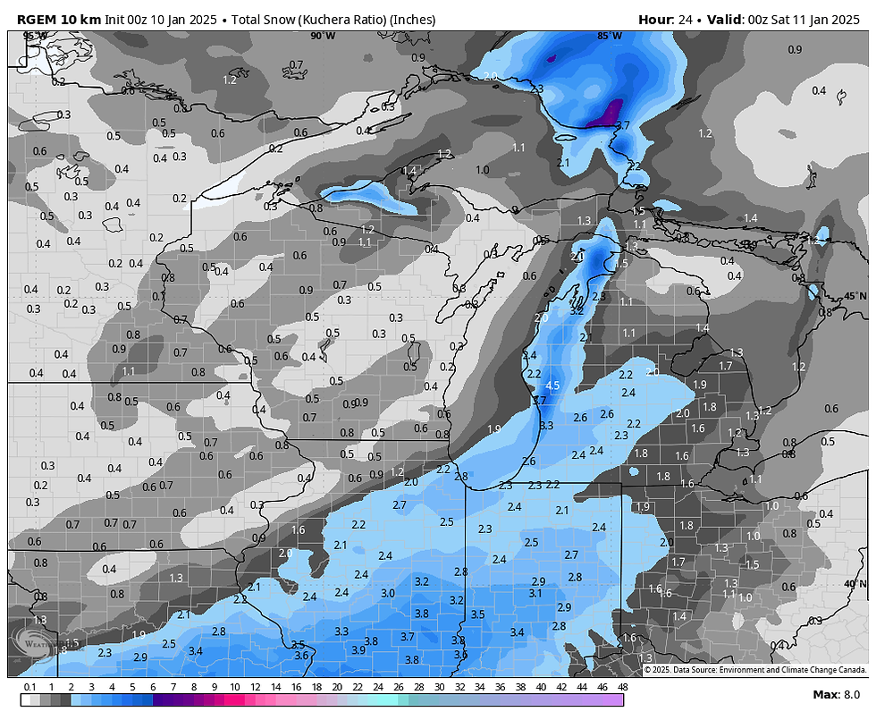
In the case of our weather Friday and again Sunday, it comes in handy to describe the amounts I'm expecting, nothing serious yet enough to track a cat and be a small nuisance in spots. The first event is underway early Friday and my area will be on the NW fringe of the snow shield. Amounts over most of the area will be a dusting or less with a few spots southeast of a line from about Keokuk to Burlington and on to Princeton seeing up to an inch. Here's what the latest guidance is suggesting for amounts.
The EURO

The GFS

The HRRR

The 3k NAM

The 12K NAM

The 10K GEM

Saturday, a weak high pressure settles over the Midwest, leading to quiet and seasonal conditions. Highs should be in the upper 20s north to the low 30s south under partly cloudy skies.
Saturday night and early Sunday, a clipper sneaks southeast across southern Minnesota before recurving northward into Wisconsin. That track actually puts us in the warm sector of the system, with highs that range from 32 north to perhaps 35 in the far south. Warm air advection ahead of the disturbance should develop a short period of light snow that comes through late Saturday night and Sunday morning. By the time it tapers off, some drizzle or freezing drizzle could briefly replace it as the dry slot passes. No doubt the heavier snow will fall further north in Minnesota and Wisconsin, where 1-4 inch amounts will be common. Parts of my area could see a quick inch or so of accumulation, with the north most favored. Honestly, this looks pretty marginal, and even the tracking cats are not impressed at this point. I suspect the higher totals are just that, high! Confidence is low on anything more than an inch. Here's what a few models are currently suggesting for snow.
The EURO

The GFS

The 12K NAM

The 10K GEM

A healthy punch of cold air will follow the clipper, arriving Sunday night and lingering into early Wednesday. Sub-zero wind chills are definitely on the table Monday and part of Tuesday. Following a brief warm-up the middle and end of next week, more cold air follows after that. As for snow, it appears the drought continues locally, with the EURO showing this for amounts through January 25th. Ugh, the black hole lives!

That's all I have for now. I'm writing this in the emergency room of Finley Hospital, where my 95-year-old mother who lives with me is a patient. She fell and broke a rib. She's got some impressive bruises, but we are very happy and thankful it wasn't any worse than that. A long day though. Happy Friday and roll weather...TS
HOLIDAY SALE CONTINUES AT OUR GALENA AIRBNB (CLICK BANNER)
40% off a weekend or weekday stay in December-February. Call or text Carolyn now at 563 676 3320.


Comentarios