


COOKING WITH NATURAL GAS...
Wednesday ended on a splendid note but it did have some rough spots, especially in the morning when showers and a few thunderstorms marched across the region. Once again there were some spotty heavier rain amounts up to 3/4 of an inch in the far south. However, as I outlined could happen yesterday, amounts were far lower than models projected with most locations picking up less than 1/3 of an inch. The reduction in totals was tied to the big MCS that tracked just to the southwest. It limited moisture and dynamics and kept totals lighter. Here's the Doppler estimates, Notice the heavier amounts of 1-2 inches from SC Iowa into Missouri where the MCS tracked.

Weak ridging behind Wednesday's system will provide the region with another good day Thursday. Under mostly sunny skies highs should reach 75 to 80. A pleasant NW breeze will keep things nice and fresh.
Friday, another disturbance (similar to a clipper) drops southeast in the NW flow and again will be a rain producer. However, I'm still of the idea the worst of the system will remain over the west and south. Amounts should be significantly lighter northeast of the Quad Cities. Conversely, chances will go up for higher totals the further southwest you go in my area, especially in SE Iowa and WC Illinois. I still would like to see better consistency among solutions and would emphasize confidence regarding amounts is low, but moderate to high that areas SW of the Quad Cities will see the majority of what ends up falling. Here's what models are suggesting.
The EURO

The GFS

The 12k NAM

The HRRR

The 3k NAM

Temperatures Friday with considerable cloud cover and some precipitation should be cool by June standards in the upper 60s to low 70s.
After this a warm front begins a slow push northward into my southern counties Saturday. As warm air advection ensues at least scattered showers and storms are possible late Saturday and Sunday, mainly in the northern half of the area closer to the slow moving front. The south is more likely to become capped decreasing the rain threat there.
Beyond this, the forecast gets muddled as the EURO goes ballistic and starts cooking with natural gas (in this case air) sending readings well into the 90s Monday over the south with low to mid 80s north. Tuesday it continues to fry with 90s over the entire area and some highs near 100 in SE Iowa. The model has consistently shown this for 3-4 days. Here's what the EURO depicts for highs Tuesday and Wednesday.
Tuesday:
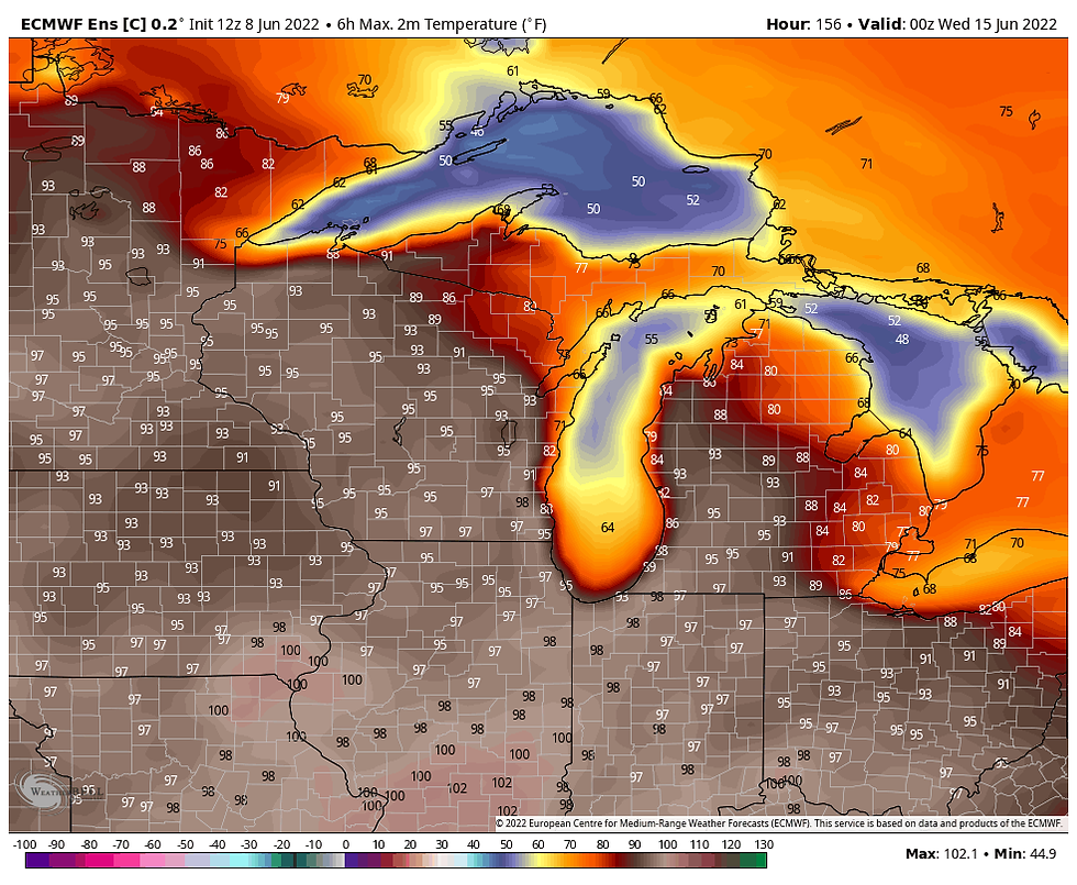
Wednesday:

The EURO ensemble control shows the heat breaking a bit late next week and then rebuilding next weekend. By June 20th it shows highs in SE Iowa as warm as 106 degrees in Mt. Pleasant! I am very skeptical of numbers like that and would say chances are low of it occurring.

The GFS is NOT BUYING what the EURO is selling. Here's what it shows for highs Tuesday and Wednesday.
Tuesday:

Wednesday:

While the EURO has its 106 high in SE Iowa near Mt. Pleasant on the 20th, the EURO shows a 68...nearly a 40 degree difference!

Usually the EURO is good at catching trends associated with heat, not so much when it comes to cold. However, I'm at a loss as to what to make of its extreme solutions, especially with the GFS in a different universe. Both of their mass fields at 500mb are reasonably close with the GFS only about 3-4 degrees cooler at 850mb. I do expect some significant heat early next week but I feel at least for the moment, a compromise approach is in order until one of the models decides to go up or down. Stay tuned on that front. No matter what, I do see a summery pattern evolving in the 6-10 day period with above to well above normal temperatures.
With that, I will put things on pause and wait until tomorrow to ponder this intriguing conflict. Until then, have a sensational day and roll weather...TS


Comments