BATTEN DOWN THE HATCHES...
The long awaited winter storm is knocking on the door. Today is the day to batten down the hatches as quiet conditions prevail through the day (the calm before the storm). Wednesday night, the Arctic hounds are cut loose and so begins our encounter with snow, powerful winds, and frigid temperatures.
Trends the past 36 hours have been for a faster more progressive system. That's significant in that it limits moisture as well as the amount and length of forcing necessary for heavy snow. As I've said all along, confidence in the snowy aspect of the storm is far lower than that of the wind and cold which have always stood out as major players. In fact, expected snow totals could still go up or down a bit more Wednesday depending on the final track and intensity of the incoming energy. This part of the forecast will continue to be fine tuned well into Wednesday.
SNOW
With almost all of our classic winter storms, we have what's known as a deformation band (or wrap around snow). With this system, we miss out as that does not come into play until the storm "bombs out" to our east. Most of our snow comes with two periods of forcing. The first Wednesday night impacts the NW half of my area (especially NW of a line from Washington, Iowa to Maquoketa, and Freeport, Illinois). The second wave is post-frontal, forming behind the Arctic front early Thursday catching all of my area as it quickly streaks E/NE during the day Thursday. Both waves have the potential to bring 2-3" of snow. The NW half or so of my region gets in on both bands and as a result sees the highest accumulations on the order of 4-6 inches. The SE with one band ends up in that 2-3" category. Had a classic deformation band formed, amounts would have been significantly higher in all locations.
The snow quickly tapers to flurries or snow showers late Thursday or Thursday evening as the energy shifts east. While some flurries will linger into Friday nothing more than a dusting is expected beyond Thursday evening. As it stands now, with the heavier accumulations likely in my NW counties, a winter storm warning has been issued for that area by the NWS. My southeast counties remain under a winter storm watch awaiting newer data regarding snowfall there.

Here's a larger view of all the hazard advisories in effect Tuesday night.

These are the odds of snowfall exceeding 3 inches around the Midwest with the storm.
The GFS

The EURO

Here are the latest snowfall outlooks off the models Tuesday night. Remember, this is just raw model output and are not forecasts. This is the guidance we use to formulate them.
The EURO

The GFS

The 3K NAM

The 12K NAM

The Canadian GEM

The is the official forecast issued by the NWS for my area.

WIND AND COLD
Both the wind and cold with this system are going to be high impact players. Here's what's driving the wind. A 975mb surface low over Michigan and a 1050 high over western North Dakota. Look at the packed isobars. If this verifies what a wind machine this storm will be.

The extreme pressure gradient depicted above creates 10 meter wind gusts of 45-55 mph. The NW winds are going to roar!

With fresh powder on the ground it's likely that visibility will be drastically reduced in the open country. Whiteouts are a possibility late Thursday and Thursday night (potentially into Friday in spots). Fortunately little snow falls when winds are at their strongest or we would have a full fledged blizzard on our hands.
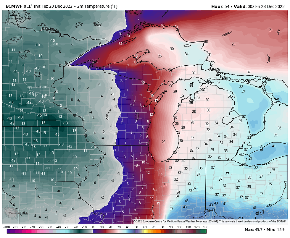
Another concern with the system is the speed that the Arctic air comes in with. At 6:00am Thursday my area is in the 20s north to near 30 south.

Just 12 hours later at 6:00pm the EURO has readings in the range of 5-10 below zero! Temperature drops of 20 degrees can be expected in less than 3 hours when the front hits.

Wind chills Friday morning will be 35-40 below all around the central Midwest.

The rapid fall in temperatures, increasing winds, and falling and blowing snow could catch holiday travelers off guard Thursday. Keep aware of conditions. Additionally, Thursday night and Friday with extreme wind chills and possible whiteouts in the open country, travel may not be not advised unless absolutely necessary. This potential is something you should not take lightly, especially outside of town.
Christmas Eve day is still plagued by high winds and bitter cold. Daytime highs will be hard pressed to reach zero and may not make it where snow cover is deeper in the NW. Christmas has brisk winds but not to the degree of the previous 3 days. Highs should sneak into the single digits but at least Saturday and Sunday will be dry. Later Christmas night most models are hinting at some sort of clipper that could at least produce another round of light snow. That is the least of my concerns right now.
I will no doubt be updating the progress of the storm throughout the day Wednesday so check in if you are interested. I plan to do one or two live Facebook hits so watch for that. I will try to send out an announcement ahead of the hit so you can be aware of the time. Thanks for visiting and roll weather...TS


댓글