A WILD RIDE AHEAD...
- terryswails1
- Feb 11, 2023
- 4 min read
PLEASE SUPPORT TSWAILS... THE FUTURE OF THE SITE DEPENDS ON YOU, ONLY 35% TOWARDS MY GOAL.
Hi everyone, as you know, TSwails.com is a no-pay site; we exist on what I call voluntary subscriptions or personal donations. Every year I ask those of you who find value in the site to make the financial donation you feel is worthy. Your contribution, whatever you can swing, supports the content, infrastructure, and operational costs of TSwails.com. To read more about my story and make a donation, CLICK HERE Thanks, it's a pleasure to serve you!
A WILD RIDE AHEAD...
The sun was back in our skies Friday as our post storm weather turned quiet but crisp. Under the influence of high pressure the pleasant weather will continue through the weekend and into Monday of next week. Temperatures look to gradually warm and will be above normal. Highs this weekend will remain in the range of 35-40 in snow covered terrain. However, where the ground is bare highs Saturday should reach the low 40s southeast and by Sunday, the same area could go into the mid to upper 40s with a southwest breeze. It all adds up to a weekend that looks and feels good.
AN ACTIVE AND POTENTIALLY WET PERIOD AHEAD
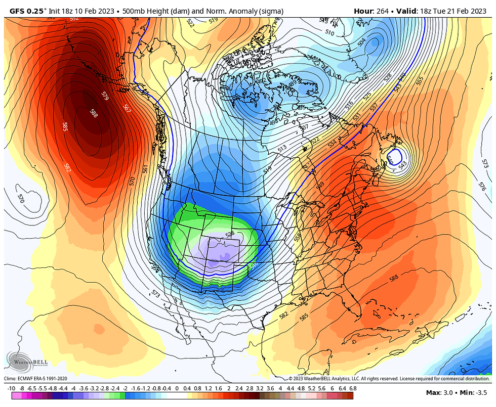
Following another stellar day Monday, the pattern reverts to one comprised of an east coast ridge and a west coast trough. That establishes a southwest flow that's both energetic and active with several disturbances likely during the period February 14th-23rd. Here's what the 500mb jet is projected to look like on the EURO February 21st.

My area resides in close proximity to the 500mb storm track with cold to the west and warmth out east. The EURO depicts temperature departures of 30 below normal to the NW and 30 degrees above normal to the SE January 22nd.

That 60 degree contrast is fuel for storms. With at least 3 individual disturbances tracking along the thermal gradient February 14th-24th, readings in the end may turn out close to normal during the 10 day period but coud be far from it on a daily basis with readings up one day and down the next as storms come and go.
The first batch of energy to contend with ejects out of the Four Corners region Monday night. As the 500mb low tightens it becomes negatively tilted causing it to pivot over western Iowa late Tuesday. That track keeps thermal profiles warm enough for rain Tuesday afternoon and night. With decent forcing and moisture, a light to moderate precipitation event looks likely with amounts of 1/4 to 1/2 inch. Here's what the GFS and EURO are indicating for rainfall.
The GFS

The EURO

Once this storm departs the mean trough remains anchored over the southwest. Another batch of energy digs into the base of the trough and deepens. In time, it promotes a stronger system Thursday that is likely to produce heavy snow and wind in the cold sector NW of the surface low, with rain and perhaps a few thunderstorms in the warm sector to the SE. It's still too early to know the precise impacts on my area as the timing, intensity, and track of the system remain unresolved. That said, the latest trends favor the storm center passing over SE Iowa indicating a rain event for the majority of my area. That's the way I'm leaning at this point in time.
Another disturbance is expected around February 21st with the potential to produce more rain (perhaps some snow) as the SW trough reloads and sends another well organized storm towards the Midwest. Without a doubt, the pattern is highly amplified pointing to moisture endowed systems, unusual for mid February. Over the period February 14th through the 26th the GFS indicates total precipitation that looks like this.

The EURO for the same period shows good consistency leading to a high level of confidence this early in the game.

The upper Midwest is likely to see some exceptional snows over the 5-15 day period. The GFS indicates this for snow totals through February 25th

The EURO is quite impressive too and comes closer to impacting my northwest counties, although the worst still remains just a tad to the northwest.

As pleasant as the next 3 days will be, the following 2 weeks look to be filled with storms or promises of storms. Whether it's rain, snow, or some combination of both, It should be a wild ride February 14th through the 25th. Until then, nice conditions prevail. Roll weather....TS
I'VE GOT A FANTASTIC DEAL FOR YOU, STILL SOME DATES OPEN...
TWO NIGHTS FOR THE PRICE OF ONE...REALLY
Hey everybody, February is the love month and boy do we have a "lovely" deal just for you at my new Airbnb, The Little White Church of Galena. If you book one night, the second one is on "us." totally free. As we celebrate our Grand Opening Month, it is a $500 value. The offer has been such a hit we are extending it into the spring. Come check out the splendor of the church which includes three bedrooms and three full bathrooms. Each bedroom has its own television and ceiling fan. The master suite has an ensuite, private deck and king sized bed. Plus a fireplace, Dish TV and Sirius XM with a great sound system. It's loaded.
Just minutes away from Galena, we have a special spot for you and your sweetheart. With all the space, you can spilt the church with one or two other couples making it a tremendous deal. It is a first come, first serve proposition as far as available dates are concerned. It truly is a religious experience! Call carolyn at 563 676 3320 or you can email at carolynswettstone@yahoo.com to secure a date or get more details. Here is a link with pictures. https://www.tswails.com/galena-airbnb


Comentários