


A DOUBLE SHOT OF SHIVER
- terryswails1
- Jan 15
- 3 min read
We're halfway through January, and all things considered it's been a cold month for the nation east of the Rockies. Here's the monthly temperature departure so far.

The reason it's so much colder relative to average from Kansas and Missouri east is the snow pack on the ground from a couple storms that have missed further north. Here's the seasonal snow for the country. Places in Mississippi, Alabama, and Georgia have had more than most of us locally.

At least in the short term, the worst of this cold snap is coming to an end. After a cold morning Wednesday, with readings around zero to 5 above, high pressure drifts east, allowing a return flow of southwesterly winds and downsloping over the Plains. Most of us will rebound into the low to mid 20s by late afternoon. Wednesday night steady or rising temperatures are expected, allowing highs Thursday to break into the mid to upper 30s. Finally, strong warm air advection ahead of an Arctic front will produce a real January thaw Friday with highs reaching the low to mid 40s, perhaps nearing 50 in the far south.
HOLIDAY SALE CONTINUES AT OUR GALENA AIRBNB (CLICK BANNER)
40% off a weekend or weekday stay in December-February. Call or text Carolyn now at 563 676 3320.

THE END OF THAT PARTY
That party (nice while it lasted), comes to a screeching halt by Saturday morning as Arctic air once gain infiltrates the pattern. You can see why, looking at the 500mb height anomalies this weekend. The door is wide open to the Arctic, the source region for our air mass, and down she will come.

The fascinating aspect of this set-up is the 1059mb high (31.27 inches) that builds into NC Wyoming Monday. That's a big boy, only 5mb short of the all-time lowest pressure measured in the contiguous United States in 1983.

Roughly a mile up at (850mb), temperatures in NW Wisconsin are shown as low as minus 34! That's wicked, true Arctic air.

The GFS shows -30 at 850 Monday in Dubuque, with -29 in the Quad Cities. For perspective, the lowest 850 temperature ever recorded in the Quad Cities is -29.5, December 24, 2022. Records go back to 1995 at the NWS office in Davenport, where the observation was taken.

Thanks to the fact there will not be snow cover, and there will be some wind, temperatures will not be nearly as cold as they could be at the surface. Even so, -5 to -10 is very much on the table.

Wind chills on the order of 15 to 25 below zero are indicated on the EURO. Some in northern Wisconsin are below -40. That sucks!

The Climate Prediction Center 6-10 day outlook January 19-23rd has very high chances for much below normal temperatures focused on the center of the nation.

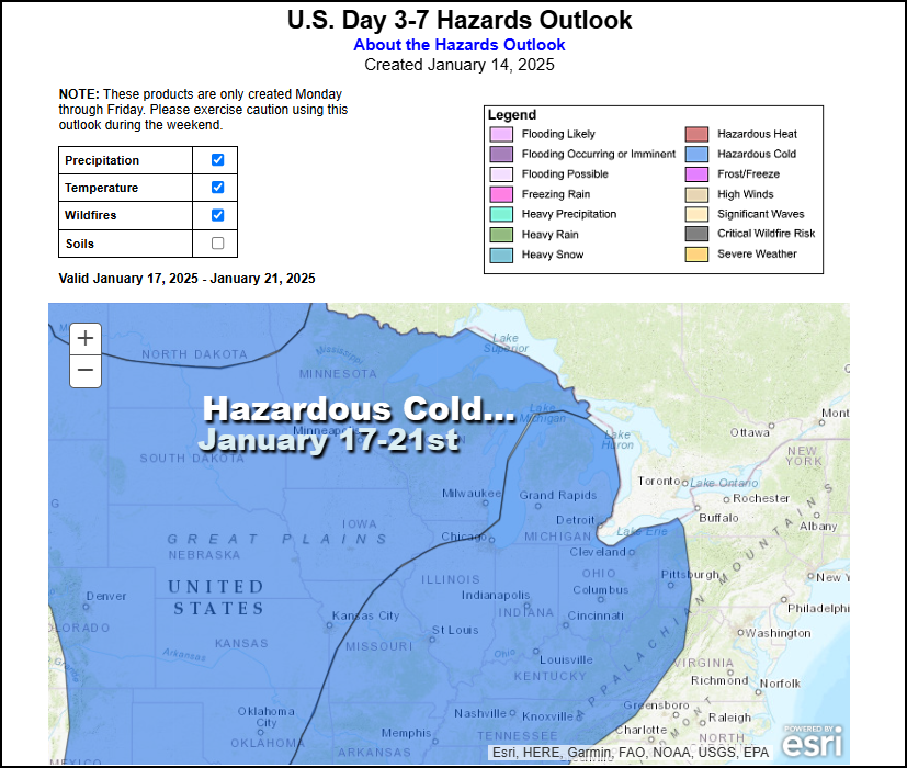
The Weather Prediction Center also has a wide are highlighted for hazardous cold in the period January 17-21st.
As I indicated in my last post, the depth and amount of high pressure means very dry air is (and will be even more so), entrenched over the Midwest by late weekend and next week. Over the next 16 days, the GFS shows this for total precipitation. Basically, my area is high and dry through January 31st.

So far, I've had no measurable precipitation through the first 15 weeks of January. If nothing falls the next 16 days as indicated, that would run the dry streak out to 31 days here, which would make this the driest January on record in Dubuque. What the heck!

Obviously, this does nothing to help the snow drought. I know you guys who plow for a living are itching to hear some positive news, but I think snow chances look very minimal through late January. I have seen some inklings of a better pattern in early February but the way this year has gone, I would not get your hopes up yet. The GFS indicates this for snow through January 31st. The black hole lives for now!

Well, as I sign off late Tuesday night, the temperature in Cedar Rapids is 3 below and zero in Dubuque. We've got a nice hole to dig out of today. That said, by Friday we are in the 40s and making an attempt at a thaw. Don't be deceived, it's not long for our world here in the Midwest. So take it in and enjoy it, the hammer comes down
later in the weekend. Roll weather...TS


Comments