SOME FRESH SNOWFALL FORECASTS
WOULD LOVE FOR YOU TO JOIN US FOR AN ALL NEW WEATHER SCHOOL: SEVERE WEATHER 101
We have a brand new weather school planned for April 4th. This one is called Severe Storms 101. If you want to know more about the ins and outs of severe thunderstorms and how to forecast them this will be a great introductory session. There will be event simulations and a big focus on tornadoes. Some tips on chasing them as well. Aside from that there will be in depth focus on the 1968 EF5 Charles City tornado outbreak, the Parkersburg EF5 of 2008, and the rare mid-November EF4 Washington, Illinois twister that occurred November 17, 2013. Lots of compelling video and insights presented by 3 meteorologists. Contact Carolynswettstone@yahoo.com to sign up or click on the more details button in the graphic above to find out more!
SOME FRESH SNOWFALL FORECASTS
Well, I'll tell you this. Somebody is going to come out of this winter storm with some egg on the face. As you know there are winter storm watches out all the way back to the west of Ames and Des Moines.

The winter storm strength and impact scale has moderate to major impacts over most of central and eastern Iowa.

The NWS snowfall forecast shows 8-12" totals from Cedar Rapids and Iowa City to Dubuque and Davenport.

That all looks very grim until you look at the latest EURO. This is what its recent snowfall forecast came in like. No more than 1" in any of those towns I listed above except for the Quad Cities where 2-4" amounts are shown.

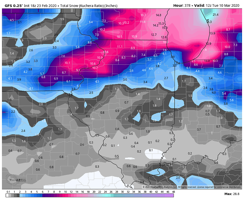
So what are the current watches and snow figures based on? I would have to assume it's the GFS and other U.S. generated models. The GFS produces snow accumulations that look like this. 10" in Iowa City and 10.6" in Davenport.

If you come to this page often you know that I am not a big fan of the GFS. The EURO consistently beats it like the stubborn mule it is, especially when it comes to picking up trends first. Now I can honestly say I am not God's gift to forecasting, but I would be super concerned if the best model on the planet was not showing as much as an inch of snow over half the area under the winter storm watch! But that's just me.
Now when it comes to other parts of Illinois and a little bit of SE Wisconsin it's another story. There the watch is very much in play and highly warranted.
Since there is no right or wrong answer yet, I could be wrong as a warm beer. If that's the case I'll take my lumps and slither away. However, I believe at this point the trends favor the worst of this system near and east of the Mississippi, especially central and NE Illinois where some big-time snows are possible. In eastern Iowa though amounts could end up very lean.
The one concession I would ask for is another 12 hours to sort this out. If the EURO has not made a move back to the north by noon Monday I think much of my area is going to come out of this much much better than it looked 24 hours ago (and for that matter, what some forecasts are still pointing towards tonight).
I just want people to know there is still some uncertainty but in my opinion the risk of heavy snow has really gone down in much of eastern Iowa today. I would suggest keeping an eye on the situation knowing full well there is still time for a last minute correction back north, although I think the chance is low. Stay tuned and roll weather...TS


